Go iLawn? It’s Just Like…
We’re gearing up for GIE 2018, so come to Louisville on October 17-19th and try New Go iLawn yourself in Booth #9055.
GIE is one place we meet people who don’t know about Go iLawn. And when we tell them what it does, we sometimes get the response… “Oh, so it’s ‘just like Google’”
Well… No, no it’s not.
I get the comparison… but no. We’re not “just like” Google’s mapping tool. This comment begins a conversation that starts with obvious things like picture quality, drawing tools and data preservation and can end up going deep into all the small details.
It’s hard to tell someone face to face in just a minute or so, all the ways Go iLawn gives them more than the basic measuring capability provided by Google or others.
So today we’re publishing this short list that details some big differences:
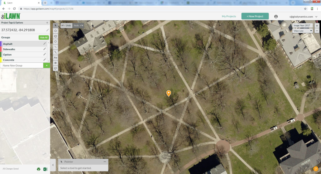
#1 The Photos:
Go iLawn uses Airplane Photography for high-quality coverage across most of North America, and our photos are taken in the winter when tree canopies are reduced. As far as we can tell, Google’s images are always taken from a satellite, and they often seem to include trees with full leaf canopies, so you can’t really see the surface beneath.
This is the easiest difference to show. Try it for yourself:
Check out the picture above, then compare it to the same spot on any provider you might use (Google or any other). Here’s the coordinates: 37.572432, -84.291808 . Paste those numbers into your search bar and see what you they show you.
The photos will show a big campus green at Berea College in Berea, Kentucky. The green is dotted with mature deciduous trees and crossed by paved walkways that you can see clearly with Go iLawn.
Go iLawn lets you see the trees, but you can also see THROUGH the trees to view and measure the surfaces below. Let us know in the comments if you get anything like this with ANY other tool!
#2 The Tools:
Go iLawn’s Drawing Tools, Groups, and Data Preservation are powerful tools to help turn the Pictures you look at into Data you use to build a Systems-Driven company. We don’t know of ANY other system that gives you this power to build a data-based model of your jobs.
- Use our Drawing Tools to measure, sort, count, categorize, and differentiate the parts of your job-site.
- Our tools let you measure areas, distances and counts, and our labeling tool puts text onto the screen for making notes about the photo, the job or the client.
- Our Groups give you the ability to segment measurements into types.
- Groups can designate whatever is meaningful to how you bid the job.
- Create custom groups for how you quote work. Group by:
- The kind of surface
- Equipment you’ll use
- Crews doing the job
- The order of completion
- …or anything else that makes sense to you
- Each group has unique colors and patterns, to reveal job details at a glance.
- Go iLawn’s Data Preservation keeps your work safe, with convenient ways to save and export your data.
- Every location is automatically saved as a project
- Projects are auto-saved every time you modify them
- Your work is always available and always up to date
- You can export photos of your job-sites and spreadsheets of your measurements
- You can share your work with customers and crews
- You can integrate your measurements with an estimating program, your CRMs, ERPs or other software
#3 The Support:
Go iLawn is backed by professionals with deep experience in running and supporting service industry businesses. We’ll train you how to use it, work with you to resolve any issue you have, and basically provide detailed personal support any time you call us at 1-(800) 270-6782 during normal business hours or email us at [email protected]
#4 The Overall Effect
There are a host of other, small benefits to using a system that was designed for your service industry businesses over a general purpose tool designed for everyone. Here’s a quick bullet list of some other things worth noting:
- More Accurate – Go iLawn’s closer zoom and higher resolution means the measurements you make are more granular and have less margin of error.
- More Efficient – Go iLawn is built for professionals, not hobbyists. Speed and efficiency were considered throughout the design process, so you’ll get more done faster.
- More Views – Go iLawn offers multiple images of the job-site. Many locations have 11 different views to choose from, so you can see from all angles and at different times.
- More Consistency – With Go iLawn, you can set up custom groups, so your categories and color coding get applied to every site you measure, every time you use it.
- More Designations – Go iLawn allows you to name each site, each group, and each measurement, to give meaningful tags that help everyone understand the job.
The Bottom Line:
Go iLawn offers unique capabilities that aren’t available in ANY other solution. These abilities are great on their own, and they can be even more powerful when used in conjunction with other tools like general purpose search engines, other mapping tools, and traditional site visits.
Go iLawn gives you something you don’t get anywhere else because of the unique way it combines mapping, drawing, displaying, and saving capabilities.
So don’t be tempted to make a comparison that only looks at part of the picture.
Try It:
But don’t just take our word for it. Try Go iLawn for yourself and see what a difference it can make for your business.
Visit Go iLawn to request your free Trial.
Or try Go iPave, our software designed for Asphalt Maintenance pros.
Thanks ~ The Go iLawn / Go iPave team.
")


Leave a Reply
Want to join the discussion?Feel free to contribute!